The Collapse of the Peat Swamp
 |
 |
 |
 |
 |
 |
 |
 |
 |
|
Explanation |
|
|
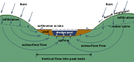
According to Emmett O'Loughlin, hydrologist: Wingecarribee Swamp lies along a narrow valley running E-W between Robertson and Moss Vale and the bulk of the runoff at times of heavy rain comes from the hills on either side. This sinks quickly through the permeable soil to the subsurface water table and is then pushed up under dynamic pressure towards the surface through gaps and voids in the peat matrix where it upwells, breaks the surface and continues downstream by overland flow.
The major void in the swamp was the "Dredge Pool" where a pontoon-mounted dredge had dug out peat for many years. Emmett O'Loughlin presented graphic evidence at the Mining Warden's Inquiry that the Dredge Pool was a major point of vulnerability in the Swamp where most of the upwelling at times of heavy rain would concentrate (See diagram above) but his evidence was ridiculed, ignored or kept under wraps. Some 200mm of rain fell on the catchment On Friday August 7th —about the same as a previous deluge in June 1991, which had no visible effect on the swamp. But this time the swamp collapsed the following day. Why this time? What had changed between 1991 and 1998? One reason was that the extraction rate had escalated in recent years expanding the area of the dredge pool from 4.7ha in 1990 to 20.8ha in 1996. (By 1997 it extended right across the swamp from one shore to the other.)However there was a more direct mining-related reason. On the night of Saturday August 8th, upwelling in the dredge pool lifted the abandoned pontoon dredge (and crane), from its anchorage and washed it 1500m through the "Buffer Zone" into the (Wingecarribee) Reservoir, tearing a channel through the peat and allowing flood waters to rush through, leading to the collapse of the swamp.
Source: David Tranter, Robertson Environmental Protection Society (REPS), 1998. Emmett M. O'Loughlin, Exhibit 75, 1997 Mining Warden's Inquiry Emmett M. O'Loughlin, Mass Movement in Wingecarribee Swamp on 8-9 August 1998: Likely Causes and Rehabilitation, 25 August 1998.
|
Home
| Story in Brief
| About Peatlands
| Value of Swamp
| History of the Swamp
Mining Impacts
| Role of Government
| Collapse of the Swamp
References | Glossary
| Site Map | Credits/Contacts
http://www.herinst.org/wingecarribee/