Value of the Swamp

As a Unique Ecosystem

Wingecarribee swamp was unique for a number of reasons:

the largest montane peatland in southeastern Australia
the largest of its type in mainland Australia
one of the best examples of an upland peatland in NSW
a very significant representation of a peatland ecosystem
one of the few peatlands developed on a sandstone rock base
an extensive rushland/sedgeland swamp dominated by plants of the Lepyrodia genus

Wingecarribee Swamp Wingecarribee Swamp, mining dredge pool and Wingecarribee reservoir in distance

back to top arrow

Extract from Directory of Important Wetlands in Australia 1996:

Wingecarribee Swamp is a remnant of a probably larger, late glacial swamp overlying the Triassic sandstone and Wianamatta Shale. Much of the original swamp would have been removed by the combined rejuvenation of the Wollondilly, Nepean and Lower Shoalhaven catchments resulting from the last uplift of the sandstone plateau. Wingecarribee Swamp survived due to an unusual combination of geomorphic phenomena: it is surrounded on the north, east and south by low basalt hills which protect it from capture by tributaries of the Nepean and Shoalhaven River, leaving a small outlet to the west into the gently west-dipping Wollondilly catchment...

As a peatland, the site must be classed as "outstanding" due to its size, at approximately 30 x 106 cubic metres.

According to the Biodiversity Group of Environment Australia:

Wingecarribee Swamp is an outstanding, if not unique, montane peatland which is vital for maintaining water quality to Wingecarribee Reservoir" and it would have met The Criteria for Identifying Wetlands of International Importance.

back to top arrow

According to Dr Geoffrey Hope, ANU:

New South Wales has few peatlands except in the alpine area, due to its dry climate which encourages rapid oxidation of organic debris. I found only ten major peatlands in southern montane NSW, each with distinctive vegetation and peatland structure. In general these peatlands are about 12,000 years old, expanding under humid conditions since the end of the last glaciation. The swamps are topogenic, meaning that they exist because of unusual topography and groundwater inputs that supplement precipitation.

The swamp is described in a major compilation of global peatland data [Peatlands of the World] and it is recorded in the Register of the National Estate for outstanding natural values.

back to top arrow

According to Emmet O'Loughlin:

The catchment of Wingecarribee Swamp has the highest rainfall in New South Wales (1600mm per annum) which flows into the swamp not only from the upstream catchment as a surface flow but also from the adjacent hillsides as a lateral input which feeds the water table and enters the swamp from below by upwelling.


References:

Roslyn Blackley, Samantha Usback and Kate Langford, eds, Directory of Important Wetlands in Australia (ed.2.) Australian Nature Conservation Agency, Canberra,1996.

National Parks and Wildlife Service, Submission to the Mining Wardens Inquiry into Possible Renewal of Mining Leases for the Extraction of Peat from Wingecarribee Swamp, 1997, Exhibit 23, pp. 6-7.

Dr Geoffrey Hope, Senior Fellow, ANU, Submission to the Mining Wardens Inquiry into Possible Renewal of Mining Leases for the Extraction of Peat from Wingecarribee Swamp, 1997, Exhibit 34.

Malcolm Forbes, Assistant Secretary Sustainable Water Branch, Biodiversity Group, Environment Australia, Mining Warden's Inquiry, 24 April 1997, Exhibit 99.
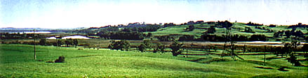
back to top arrow


This site has been designed, researched and produced by Sharon Beder

Wetlands | Ecosystem | Habitat | Historical | Water Quality


Home | Story in Brief | About Peatlands | Value of Swamp | History of the Swamp
Mining Impacts | Role of Government | Collapse of the Swamp
References | Glossary | Site Map | Credits/Contacts

http://www.herinst.org/wingecarribee/