The Collapse of the Peat Swamp
 |
 |
 |
 |
 |
 |
 |
 |
 |
|
Events |
|
|
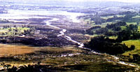
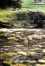
Heavy rain on Friday August 7th 1998 (200-300mm) lifted the abandoned pontoon dredge and washed it 1.5 km through a buffer zone (supposed to protect the Wingecarribee Reservoir). The dredge ended up in the Reservoir.
"The swamp had collapsed, its whole topography and geography transformed overnight. A Wetland of National (perhaps international) significance was reduced to a torn and twisted wreck" which may take hundreds of years to fully rehabilitate.
Source: David Tranter, Robertson Environmental Protection Society, 1998. David Tranter, 'Case Study: Wingecarribee Swamp', Water: Wet or Dry?: The Proceedings of the Water and Wetlands Management Conference, November 1998, Nature Conservation council of NSW, August 1999, pp.90-97.
|
Home
| Story in Brief
| About Peatlands
| Value of Swamp
| History of the Swamp
Mining Impacts
| Role of Government
| Collapse of the Swamp
References | Glossary
| Site Map | Credits/Contacts
http://www.herinst.org/wingecarribee/